Rosenberg Institute Seminar Series - Alex Braud
Overview
Alex Braud, Coastal Geospatial Scientist, San Francisco Estuary Institute
Mapping Resilience: How Better Data Supports Nature-Based Solutions
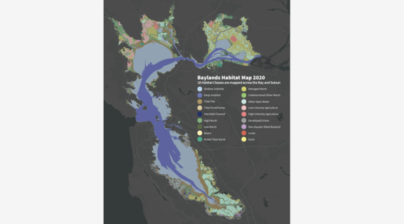
Abstract: Regional, accurate, and repeatable data are foundational to science-based coastal planning. San Francisco Bay faces mounting pressure from sea level rise, and understanding where nature-based solutions can work and how well requires knowing where coastal habitats exist, how they're distributed across the tidal frame, and how they're changing over time. Elevation relative to the tides controls habitat type and drives sediment dynamics, making it a key variable for assessing marsh condition, sea level rise vulnerability, and restoration potential. This talk covers ongoing work at SFEI to build and continuously improve Bay-wide geospatial datasets and tools that support regional monitoring programs and resilience metrics designed to inform decisions across a range of scales and applications, from project prioritization and restoration tracking to shoreline planning. Topics include automated habitat mapping, a multi-agency lidar coalition, and satellite-derived intertidal elevation mapping that integrates imagery with local water level data.
Bio: Alex Braud is a Coastal Geospatial Scientist at the San Francisco Estuary Institute, where he works at the intersection of coastal science, geospatial analysis, and resilience planning for San Francisco Bay. He develops remote sensing and modeling tools to monitor wetland change, sediment dynamics, and shoreline resilience, while contributing to the science-policy interface that drives coastal adaptation decisions. Alex holds master's degrees in Environmental Studies and Public Administration from the College of Charleston and bachelor's degrees in Geography and Disaster Science from LSU. He previously served as a NOAA Coastal Management Fellow at the SF Bay Conservation and Development Commission.
Tags